Well, I am a bit blogged out. The remaining days in Tahoe were a Blur (The 2 days I am covering now are 29 and 30 June. My legs WERE KILLING ME and I was beat down. Had some fun overall. Took one more rest day after Peter, his brother Harry, Chris V and Chris Mack and I rode from Tahoe Meadows to the Flume Trail, Marlette Lake, back to the Rim Trail and back to Tahoe Meadows. Great Views. Something like 29 miles and 3000 feet of climbing. Most of this post will be videos shot by Chris Mack and Peter.
But, the day before we did two smaller rides. Part of Kingsbury and Corral again. Found "the log" on corral. Good challenge. I was the first to ride it...no one had video, so rode it again, and then eventually most everyone got it.
Here is video from Kingsbury:
And more:
Chris V, eating it on the log...what did it take, like 4 tries before you got it?
This is how it is supposed to be done:
Some video on the Flume Trail:
Sunday, July 27, 2008
South Lake Tahoe Day 1
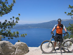
Well, I met up with some folks from MORCA that I ride with in Monterey. I was looking forward to no longer riding solo or riding with people that I don't know. I hit up Northstar for some Lift served mtn biking on Friday the 27th, and then drove down to South Lake. Parked out in front of Bobke's parent's vacation home and we rode on Saturday.
The group was Bob (who turns 60 this fall and just started MTBing seriously in the last year or so), Chris Mack (just turned 50 and still kills me on the climbs) as well as his wife Karen and we had Darren as well. Chris had the only experience riding in the area, but it was very limited experience. I had a ton of maps as well as topo files loaded onto the GPS. So, the struggle was to find a ride we could all enjoy...and then perhaps Bob and Karen could peel off and head back as Chris, Daren, and I continued on to ride. On the map, riding from town out to the powerline trail and then cold creek trail looked like a good ride that Bob and Karen could handle...and it gave the option of trying to go up to Star Lake to hit the Tahoe Rim Trail and back down to hit the Corral Trail and back to power line and then back into town.
We hit cold creek easily enough. We began climbing up and eventually Bob and Karen turned back. At some point, we saw a sign at a y-intersection. It pointed in the direction across cold creek itself. No longer in the lead, C-Mack (Chris) kept going up the trail rather than across the creek. I had the map, and it looked like maybe we should have gone across the creek. But, we couldn't tell where we were on the map in relation to the creek crossing (which had to be done at some point). Since the trail looked well traveled, it looked safe to continue on in any account.
We finally came to what looked like the end of the creek. According to the map, when we crossed the creek, we would head up on a fire road to Star Lake. Well, there wasn't much of anything on the other side of the creek. The only fire road there only went back in the direction we came. It looked like the trail we were on continued on, so we chose to go back to the original side of the creek and continue on. Soon we were pushing our bikes up a hill under some powerlines in some gravel like sand. It sucked, but we couldn't correlate our position to a location on the map. After fooling with the GPS long enough, I found star lake. Sure enough we were heading the WRONG direction. We managed to find a couple of dirt roads that lead UP UP UP to Star Lake. Much of it was hike a bike. In the last mile alone, it was 95% hike a bike climbing 1000 feet up to 9000 feet of elevation.
Some video after we figured out the wrong turn:
Star Lake was beautiful and had a very remote feel to it:
We had been out for quite a few hours already.
Something like 2.5 hours of in motion time at this point. I think we left town at 10am. I had my water filter with me, and as I tend to go through a lot, I filled up my water bottle and added another 1.5 liters to the camelback.
From there, it was mostly rideable with a little bit more climbing. I think our peak was at 9500 feet at Armstrong Pass.
The rest of the trail was FUN FUN FUN. I was so fortunate to have enough energy to enjoy the downhill. Video of Darren and I on some of the fun stuff:
Getting down the Rim Trail and then down to corral was a blast. I was having so much fun I was pushing the speed envelope on corral. Ended up going down twice because I was just going too fast. All of the fun had to end at some point and we ended up on powerline trail. At this point of the trail it was very soft sand in a lot of spots and a bit more climbing.
We made it into town. I was out of water, and a stop at Walgreens for ice cream bars and water was called for. All in all, 4000 feet of climbing...something like 34 miles of riding in 5 hours of in motion time...but it took us 8 hours total ellapsed time.
The ride aftermath: (Click to enlarge and you can see all of the dirt from having my two "off the bike experiences")
The group was Bob (who turns 60 this fall and just started MTBing seriously in the last year or so), Chris Mack (just turned 50 and still kills me on the climbs) as well as his wife Karen and we had Darren as well. Chris had the only experience riding in the area, but it was very limited experience. I had a ton of maps as well as topo files loaded onto the GPS. So, the struggle was to find a ride we could all enjoy...and then perhaps Bob and Karen could peel off and head back as Chris, Daren, and I continued on to ride. On the map, riding from town out to the powerline trail and then cold creek trail looked like a good ride that Bob and Karen could handle...and it gave the option of trying to go up to Star Lake to hit the Tahoe Rim Trail and back down to hit the Corral Trail and back to power line and then back into town.
We hit cold creek easily enough. We began climbing up and eventually Bob and Karen turned back. At some point, we saw a sign at a y-intersection. It pointed in the direction across cold creek itself. No longer in the lead, C-Mack (Chris) kept going up the trail rather than across the creek. I had the map, and it looked like maybe we should have gone across the creek. But, we couldn't tell where we were on the map in relation to the creek crossing (which had to be done at some point). Since the trail looked well traveled, it looked safe to continue on in any account.
We finally came to what looked like the end of the creek. According to the map, when we crossed the creek, we would head up on a fire road to Star Lake. Well, there wasn't much of anything on the other side of the creek. The only fire road there only went back in the direction we came. It looked like the trail we were on continued on, so we chose to go back to the original side of the creek and continue on. Soon we were pushing our bikes up a hill under some powerlines in some gravel like sand. It sucked, but we couldn't correlate our position to a location on the map. After fooling with the GPS long enough, I found star lake. Sure enough we were heading the WRONG direction. We managed to find a couple of dirt roads that lead UP UP UP to Star Lake. Much of it was hike a bike. In the last mile alone, it was 95% hike a bike climbing 1000 feet up to 9000 feet of elevation.
Some video after we figured out the wrong turn:
Star Lake was beautiful and had a very remote feel to it:

We had been out for quite a few hours already.
Something like 2.5 hours of in motion time at this point. I think we left town at 10am. I had my water filter with me, and as I tend to go through a lot, I filled up my water bottle and added another 1.5 liters to the camelback.
From there, it was mostly rideable with a little bit more climbing. I think our peak was at 9500 feet at Armstrong Pass.
The rest of the trail was FUN FUN FUN. I was so fortunate to have enough energy to enjoy the downhill. Video of Darren and I on some of the fun stuff:
Getting down the Rim Trail and then down to corral was a blast. I was having so much fun I was pushing the speed envelope on corral. Ended up going down twice because I was just going too fast. All of the fun had to end at some point and we ended up on powerline trail. At this point of the trail it was very soft sand in a lot of spots and a bit more climbing.
We made it into town. I was out of water, and a stop at Walgreens for ice cream bars and water was called for. All in all, 4000 feet of climbing...something like 34 miles of riding in 5 hours of in motion time...but it took us 8 hours total ellapsed time.
The ride aftermath:
 (Click to enlarge and you can see all of the dirt from having my two "off the bike experiences")
Lake Tahoe, Day 1

This is going off of foggy memory as it has now been a couple of weeks. I'll also try to be more brief:) The ride day was 26 June and was riding day 5 out of the first 7 days.
I made camp at a campground just south of Tahoe City on the Eastern Shore. I took the next day off and rode around town and found the start of the trailhead as well as the end, just to make sure. Tahoe city seemed like a cool place. Not as run down as Kings Beach looked.
So, the next morning, I got up and after breakfast, was on the bike pedaling out of the campground. About 2 or 3 miles to the trailhead and I hit the trail with a water crossing to start it off. I climbed up to Standford rock up 8500 feet or so after starting near the lake at about 6200 feet. Saw my first snow of the trip up around 7500 feet, and then a massive snow drift up at Stanford rock. Had a couple of nice spots for views, but with the wildfires, I couldn't see a whole lot.
From Stanford Rock, I hit the Tahoe Rim trail. Mostly down towards the meadows and into town (Tahoe City). It was fun. And a very well built trail. Nearly all, if not all water drainage crossings were heavily armored with rock...and thus very fun to ride. Saw a nice waterfall on the way down too. In this photo you can see a bit of the trail that goes by the waterfall.

The rest of the trail was lots of fun too. I think I only did 2700 feet of climbing and 21 miles. Got into town, grabbed a sandwich and pedaled back to camp. Dropped off most of the gear and headed back across the street to take a dip in Lake Tahoe...it was nice. Camped again that night and then headed around the other way of the lake to meet up with friends in South Lake Tahoe.
Subscribe to:
Posts (Atom)