Thursday, December 25, 2008

Traveling Again


Well, H and I hit the road last week. One night and one day in Yosemite. No heat in the camper that night...had a propane leak and it was too late (1am when we pulled in) to mess with. Did a day hike in the snow. There wasn't anything open yet in Yosemite to rent XC skis or snowshoes, so hike it was. Next, we went to Bakersfield to stop at H's parent's place. Rode with her Dad the next day and picked up her snow shoes too. Then hit the road for Sedona.

Lucked out pretty well with Sedona. TrailDoc from MTBR let us park in front of his house...he was even up at 1 am when we rolled into town. He is 3 months post ACL recontruction, so wasn't riding much with us the next day. And, as it turns out, I happened to ride with TrailDoc and his wife in Moab 5 or so years ago, but didn't realize the connection until we had talked a bit in Sedona. His wife was 52 at the time I rode with them in Moab and I was walking stuff she was riding/rolling. Small, small world...at least the MTB world :)

Since he wasn't riding hard (not supposed to ride at all at this point in the recovery), his neighbor Wes took me around the trails and made me feel like a) I wasn't in shape and b) I didn't have a whole lot of skill either. He was riding a much heavier Turner 6 pack and pedaled away from me on every climb. Regardless of my comparitive ineptitude on the bike, Wes was a super nice guy and it was good to ride with a friendly local (who also seemed to know everyone we came across on the trail).

The next day, I took H on the trail. She did really, really well. Rode lots of stuff. We got some good photos too....


We rode again the next day, this time a shorter ride out of West Sedona. I think H burned the candle at both ends the day before as she was really feeling it. After the ride, a little lunch, then to PV to visit my mom. Then Phoenix once again. I rode Desert Classic at South Mountain Christmas Eve...and am left wondering why it is that even the easy XC trails at south mountain always make me feel out of shape. Tomorrow, I'll probably do Morman and National at South Mountain. Then, I may hit the road to do a couple of rides while enroute to meet back up with H in Austin.

Sunday, December 7, 2008

It is good to have more than one bike...

So, Friday I did the standard night ride on the trails and then ride to the bar....have a few beers and then rode home. On the Ventana. Sunday morning, H picked up her new roadbike, so we went for a road ride.

Later today, I got in a SS ride on the formerly fully rigid SS 29er. I put a Reba Race 29er fork on the front of it Friday. SO much better! Had a good time running around the trails at Fort Ord, trying to beat the sunset. 3 different rides...3 different bikes...all good.

Now, can I get past the feeling that I am neglecting the Ventana (my true bike love) and ride the SS more frequently on the trail? Hmmmm. We shall see...though I suspect having to change pedals from commuter pedals to clipless every time I want to hit the trails with the SS will help ensure the Ventana and I maintain a good relationship....but it is always good to throw in some variety!

Update


Where to begin. Well, I rode National Trail at South Mountain in Phoenix on Thanksgiving day again this year. Only this time I didn't crack any ribs! Pic:


The day after, I rode in Sedona. Good place to ride. I was kicking myself for having never stopped there to ride on my many trips there. My mom only lives an hour away too. Actually, I did try riding there once...and it wasn't very fun, but I had limited info at the time.

Haivng now found the good information, which wasn't that hard to find at all, I'd say the riding is almost on par with Moab. Pictures kind of suck becasue I forgot the memory card for the camera so had to do the cell phone pics.


Scenery is almost on par with Moab as well.


However, the atmosphere in town absolutely BLOWS. Bunch of snobs. The trails were busy...day after Thanksgiving and all. Ran into a few folks from the bay area and a some from San Diego too, so at least as far as I could tell, the attitude from town doesn't invade the trails.


Monday, October 13, 2008

Bad Moon Rising....


This was actually the end of the ride...as viewed from the trail's end right at the main road. Not really a bad moon. I just had that CCR song stuck in my head when we first saw the moon rise on our way down the trail.

I had debated much where to ride for Columbus Day Weekend. H couldn't go anywhwere as she had to work Saturday. I couldn't get any one else to step up either. So, I was going solo.

I'd heard a lot about the "Cannell Plunge" ride out of Kernville (hour or so north of Bakersfield near the Kern River Valley) and wanted to check it out. It is about the same driving time for me (maybe slightly less) as getting to Downieville. With the weather forecast showing it to be REALLY cold in D'ville and cold in K'ville, I decided to go with the warmer option and the chance to check out a trail I have been wanting to for some time.

So, Kernville it is. I managed to get a seat on the shuttle to Sherman Pass from town with Mountain River Adventures. There were 18 folks going on today's run. I ended up riding in a van that had, of all people, the owner of the bike shop in South Lake Tahoe that Peter goes to when he is in town. Garry and his wife Becky were there with thier fellow adventure couple friends Mike and Kirby. It sounded like they were the only ones that were going to attempt the bonus climb at the top up to Sherman Peak at 9850 feet on the topo map. Because I was there, I felt that I had to do it as well.

That would at times be a decision I would regret. I think we started riding at around 10am. It was bitter cold at the drop off point at 9200 feet. Someone said it was in the teens and I believie it. Riding to the top of Sherman Pass (at times pushing the bike), my toes, fingers, cheeks and lips were stinging numb. My core was fine. I even managed to sweat. But, my face was so numb, I couldn't quite talk very well. I think it took a little over an hour to reach the top, and for the climbing portions...I assumed my position for much of the ride...the anchor. The two couples had to be in their mid to late 40's, and here I am...the weak link in the climbing portions.
The view on top was pretty good. As you are clearly at the highest point around for many miles...you can see Mt Whitney in the background.


After warming up in the sun for a bit and attempting to dry out what bits of gear we got wet from sweating, we headed back down to Sherman Pass and the trail. Did I mention it was cold? Most of the trail on the way back down to the pass seemed very similar to various parts of the Tahoe Rim Trail.

We got to the trail and the downs were a welcome break to the climbing or bike pushing. Did I mention it was cold? At some point not too far after we passed Sherman Pass, we came across a frozen stream. It had probably been 2 hours or so since the other 13 riders passed through this section. In that time, the ice had re-formed to the point that you could not tell it had any traffic. It was that cold!

We spent the next several hours doing climb-descend-climb patterns...all between 8000-and 9500 feet. We got lost a couple of times. Lots of almost nasty rock gardens. Some good fast sections. Some crappy climbs. During many of those crappy climbs...I was at the point of wondering what I had gotten myself into. I was ready to quit. I didn't want to ride anymore and felt SO out of shape. It isn't often I end up on a ride that I am ready to give up early on.

We also got lost a couple of times around Big Meadow. Most folks say that you should avoid the ride through big meadow and instead take the fire road. Well, it isn't exactly as easy as it sounds. I even had a GPS track loaded on top of the topo map on my GPS. Due to what I think is receiver error in the trees...it was hard to find the track relative to the different fire roads until we got out into the open. Big Meadow...notice in the 2nd meadow picture...we are riding through it....hence the lost portion:


After what we thought was the final climb on the fire road (also finally along what we belived to be the right track), we got to do some sustained downhill. It was now probably 3:30 pm. And still cold. However, I think we were still up above 8000 feet. We rested and ate up a bit before hitting the trail. Started out fun. Then some uphill. Argh!

Eventually we had real good (and very welcomed) sustained down hill portions. Once we got to the "Plunge" portion of the ride where you descend around 5000 feet in 8 miles, the scenery opened up in dramatic fashion:


In the center is Lake Isabella, with a portion of the trail in the lower right hand portion of the frame. At this point, the trail isn't very technical. Just fast and LOOSE. It felt like I was driving a front wheel drive car in the snow, never sure if the bike was going to go in the direction you try to point it (massive understeer for me). Garry, the shop owner...was on fire. He was absolutely flying down this section...apparently some combo of great skill, experience, and perhaps a better setup to not experience the confidence shredding understeer issues I was having.

Here is another pic, just to prove I was there!


.

And finally, we get to see the town again. Here is another shot looking at the last bit of trail. This particular section is pretty fast. I remember thinking to myself on this section: "I can't believe I am going this fast on a bike!" I have no idea how fast I was actually going since it was still too cold for my cycle-computer to function (batteries don't like the cold)


Overall, a real fun ride (minus the self doubt portions). Certainly worth the 5 hour drive. I was so tired...that if I returned home the next day...it still would have been worth it.

Now for the data points. According to my watch....3300+ feet of climbing. 9300+ feet of descent. About 5 hrs, 45 mins of riding/bike pushing. Somewhere around 32-36 miles...bike computer wasn't working and it is 32 on the GPS which is usually straight line distance. Factor in the backtracking for being lost and the distance covered due to elevation...well it is more than 32. We started the ride at 10 am and got back to the shuttle pick up point at 6 pm.

DAY 2: Whiskey Flats

I slept real well the previous night. I think I went to sleep around 8:30 pm and woke up at about 7 am. I think the last time I felt that I had been that worked over was the "Star Lake Fiasco." Maybe not even then. It was a welcome feeling of sorts. Brought back memories of trips to Moab where we'd ride all day, go into town to the Brewery for a beer or two and dinner (while sitting there with shell shocked blank experssions on our faces), go back to camp, pass out...wake up and do it all again the next day.

So, I didn't return home. After all, part of the mission objective for this trip was to scout trails to determine the fesability of taking H on the trails since her parents live in Bakersfield. I had heard of some other rides, but it looked like they were best done as a shuttle. Being solo and no shuttles being run by MRA and feeling a bit worked over still, I didn't think trying to do some of those rides without the shuttle was the smart thing to do. So, I tried to find out about other trails. Try is the key word.

I went into town to check out the MRA storefornt. I thought I'd be able to get some trail recommendations there. No joy. They had one girl working the store and she didn't ride. No maps either. Just a book that turned out to be the biggest waste of $17 I can think of. I asked here if there were any bikeshops around. She said maybe Lake Isabella. So, I drove there. Couldn't find one. Even fired up the Iphone to google "lake isabell bike" and got next to nothing usefull. Frustrated, I turned to the book.

I remember Paul and Sue said they rode Whiskey Flats when they were passing through last December. They recommended it. So, I looked it up in that worthless book. The book made it sound bad. But, I figured I'd still try to find it. Well, the book's directions to the trail head aren't quite right, but I managed to find it.

At the trailhead, I met two guys from Corona. They just got into town thinking it was kind of like D'ville where you had about an even chance of hopping on a shuttle with no reservation to get in a run. Kernville just isn't that big of a biking destination. So, they ended up tagging along as we explored Whiskey Flats. It is always nicer to ride a trail you don't know with other folks....even if they don't know it either.

This trail paralles the Kern River. Lots of Rocks in sections. Lots of short steep ups and downs...with an overall increase in elevation as you head up river. The short ups and downs seemed as steep as some sections of the Slickrock trail in Moab. Only throw in loose sand and rocks instead of super grippy sandstone surface. Yep. You guessed it (or maybe not). I was pushing the bike often again.

I read somewhere on line that someone had a good time doing the ride as a 6 mile out and 6 mile back where the whole trail is 14 miles up river. I decided that was a good goal considering the state I was in. Well, after 3 miles in...the two guys from Corona cried uncle and turned back. I pushed on...how could I only do 6 miles of riding? I tried to reach my goal of 6 miles out. But, frustration with the hike a bike portions and the eventual closing in of the trail at around 5 miles out (felt like the remaining portions of the ride were going to require lots of bushwacking), I turned back. The return trip was more fun, but again, some sections I couldn't ride up.....so I had to push. Like it seems with so many other trails here...I am guessing this would be more fun starting from the other end at 14 miles and riding it as a shuttle. Oh what fun it would be to have another person (and vehicle) to ride out there with.

Here is one of only 2 pictures I took on this ride....looking at the Kern River:


Tuesday, October 7, 2008

I don't want to move again

I still have 11 months left in Monterey before I get sent somewhere else. But, man, I really don't want to move anywhere else if only for the riding.

Last night I pedaled my bike over to the monthly MORCA meeting. Something like 8 or 9 miles away. After dinner, 2 beers...oh yeah, the meeting too...I pedaled back home. This time I was on the road bike and had my new Light and Motion Stella LED light on it.

The ride home was fantastic. Pedaling down the coastal bike path, with a 1/2 moon at 11 o'clock in the sky and some stars out with very little light other than the Stella. Cool, crisp ocean air...just cool enough to give you a chill if you are not moving with some effort...feels great moving over your skin once warmed up. No wind, other than what you make by going faster. Def Leppard playing on the Ipod, and no one else out there but me. Wheels rolling so smoothly, at times effortlessly gliding down the path with nothing but 30 feet of path illuminated in front of me, the moon, and the stars.

I'm going to miss this place when I do have to leave.

Wednesday, October 1, 2008

H does D'ville!

So, I never managed to compress the video for my last day in Tahoe way back when. Oh well. In between now and then, I did a fair amount of local riding. At least for a while. The last 6 weeks or so, school was absolutely kicking my ass....21 credits of graduate level Mech Eng courses will do that to you. But, last week I turned in my last final on Thursday Morning. I was determined to go somewhere cool to ride.

Ended up hanging around until H could get off work. I loaded put the camper on the truck and otherwise got ready. I think we left sometime around 7pm and rolled into a campsite near Downieville at about 1 am.

I had been wanting to get H to ride some neat trails with a bit more of a technical challenge than what we have been getting out at Fort Ord. Her fitness hasn't developed a whole lot, mostly due to her schedule over the summer limiting her to one ride a week a best. That and she isn't "addicted" to MTB yet (there is still hope though!). However, her confidence on the bike has taken great leaps and strides...mostly after building up the new bike for her. So, I figgured Downieville was a good option with plenty of technical challenges (all do-able) with not as much of a cardio challenge since you can shuttle the most popular runs there.

Day 1, we get up and drive to the top. There was some debate as to what the best approach was. That is, is it better to drive into town and try to get on a shuttle to the top, or just drive to the top (a hell of a lot closer to where we were camped) and hope we could catch a shuttle back to the top later on. Based on my previous experience there at the begining of the summer, I figured it shouldn't be too much of a problem for at least one of us to jump on a shuttle to go fetch the truck. So, we drove to the top with fingers crossed on catching a shuttle back up later on.

We hit the single track on Sunrise trail. I was encouraged to see H ride many features that I myself would have hesitated quite a bit just 5 years ago. She was doing really well! Then, we hit the OHV section of Butcher's Ranch. Mostly a fast paced jeep road. I looked back to see her catching little bits of air! She was having a good time! Then we hit the single track of Butcher's. I forgot how rocky it was. The rocks weren't so friendly to H. Despite being padded up with helmet, elbow/forearm pads, knee and shin pads...she managed to find enough spots of her body against the rocks on 3 separate occasions. Things weren't looking as good. But, after taking it slow and trying to talk her through some section, she got a little more confident and was soon back to having fun.

Here is a pic of H and the bike after she was having fun again:

We got down to the bottom to find that Yuba just ran their last shuttle for the day. Went to D'ville Outfitters were told they had only one shuttle left in a couple of hours and it was full, but come back by just before 3pm (the shuttle time) to see if anyone drops out. So, we grab sandwiches and I start to mentally prepare to do the 3-4000 foot climb back up to grab the truck. H talks to someone who says they are on the 2 pm shuttle with D.O. Hmmm they told us 3pm . So we go check it out and find 4 other folks looking to get in on a shuttle. D.O. guy says to check back with him after he gets back...and he *might* consider adding another run. We go to Yuba and if we sweeten the deal for the driver...we have a ride up. Sweet! I don't have to kill myself getting to the top! And we both get to go up together....


Day 2, she dropped me off at the top to get in a solo run. Plan was to meet her in town and catch a shuttle back up to the top together to get in another run together. I was having a blast sailing right down the mountain. Passed ALOT of folks on the way down. The Ventana was working well, brake issues finally behind me. Then, my rear hub started acting up. If I stopped pedaling, the cassette wanted to keep moving, slacking the upper portion of the chain. Well, the chain eventually blew up. I bent two links and flat out lost the power link. I had a spare power link with me and had to cobble the chain back up in the two spots where the links were bent. Made it into town and had the LBS look at the hub. Couldn't be fixed right away. Riding the Ventana for this trip was no longer going to happen.

However, H really wanted to get in that afternoon run and asked if I'd rent a bike so that we could do a run. Nice! After taking a beating the first day, she wanted to do it again! Unfortunately, they didn't have a Nomad or Bullit to rent...all they had left was a heckler, which is roughly comprable to the Ventana...running the same suspension setup I have on the Ventana.

So, we did the run, and apparently she had blast. Played tag with a group of 3 girls and 1 guy who were riding (2 of the girls were riding there for their first time, I think) and H made some cycling friends that added to the overall enjoyment of the run. Even better, she figured out on her own some of what caused her to go down the previous day and managed to finish her second run without going down.


Here is a pic while she shows how it is done on a bit of a drop:

And, the topping on the cake is that she wanted to ride again on Sunday! We didn't as I didn't feel like spending $100 for 1 run two days in a row (actually 75 for the bike rental and 22 for the shuttle).

Hopefully we will get to do more fun riding soon.....

Sunday, July 27, 2008

More Tahoe

Well, I am a bit blogged out. The remaining days in Tahoe were a Blur (The 2 days I am covering now are 29 and 30 June. My legs WERE KILLING ME and I was beat down. Had some fun overall. Took one more rest day after Peter, his brother Harry, Chris V and Chris Mack and I rode from Tahoe Meadows to the Flume Trail, Marlette Lake, back to the Rim Trail and back to Tahoe Meadows. Great Views. Something like 29 miles and 3000 feet of climbing. Most of this post will be videos shot by Chris Mack and Peter.

But, the day before we did two smaller rides. Part of Kingsbury and Corral again. Found "the log" on corral. Good challenge. I was the first to ride it...no one had video, so rode it again, and then eventually most everyone got it.

Here is video from Kingsbury:


And more:


Chris V, eating it on the log...what did it take, like 4 tries before you got it?


This is how it is supposed to be done:


Some video on the Flume Trail:

South Lake Tahoe Day 1

Well, I met up with some folks from MORCA that I ride with in Monterey. I was looking forward to no longer riding solo or riding with people that I don't know. I hit up Northstar for some Lift served mtn biking on Friday the 27th, and then drove down to South Lake. Parked out in front of Bobke's parent's vacation home and we rode on Saturday.

The group was Bob (who turns 60 this fall and just started MTBing seriously in the last year or so), Chris Mack (just turned 50 and still kills me on the climbs) as well as his wife Karen and we had Darren as well. Chris had the only experience riding in the area, but it was very limited experience. I had a ton of maps as well as topo files loaded onto the GPS. So, the struggle was to find a ride we could all enjoy...and then perhaps Bob and Karen could peel off and head back as Chris, Daren, and I continued on to ride. On the map, riding from town out to the powerline trail and then cold creek trail looked like a good ride that Bob and Karen could handle...and it gave the option of trying to go up to Star Lake to hit the Tahoe Rim Trail and back down to hit the Corral Trail and back to power line and then back into town.

We hit cold creek easily enough. We began climbing up and eventually Bob and Karen turned back. At some point, we saw a sign at a y-intersection. It pointed in the direction across cold creek itself. No longer in the lead, C-Mack (Chris) kept going up the trail rather than across the creek. I had the map, and it looked like maybe we should have gone across the creek. But, we couldn't tell where we were on the map in relation to the creek crossing (which had to be done at some point). Since the trail looked well traveled, it looked safe to continue on in any account.

We finally came to what looked like the end of the creek. According to the map, when we crossed the creek, we would head up on a fire road to Star Lake. Well, there wasn't much of anything on the other side of the creek. The only fire road there only went back in the direction we came. It looked like the trail we were on continued on, so we chose to go back to the original side of the creek and continue on. Soon we were pushing our bikes up a hill under some powerlines in some gravel like sand. It sucked, but we couldn't correlate our position to a location on the map. After fooling with the GPS long enough, I found star lake. Sure enough we were heading the WRONG direction. We managed to find a couple of dirt roads that lead UP UP UP to Star Lake. Much of it was hike a bike. In the last mile alone, it was 95% hike a bike climbing 1000 feet up to 9000 feet of elevation.

Some video after we figured out the wrong turn:


Star Lake was beautiful and had a very remote feel to it:
We had been out for quite a few hours already.
Something like 2.5 hours of in motion time at this point. I think we left town at 10am. I had my water filter with me, and as I tend to go through a lot, I filled up my water bottle and added another 1.5 liters to the camelback.

From there, it was mostly rideable with a little bit more climbing. I think our peak was at 9500 feet at Armstrong Pass.

The rest of the trail was FUN FUN FUN. I was so fortunate to have enough energy to enjoy the downhill. Video of Darren and I on some of the fun stuff:


Getting down the Rim Trail and then down to corral was a blast. I was having so much fun I was pushing the speed envelope on corral. Ended up going down twice because I was just going too fast. All of the fun had to end at some point and we ended up on powerline trail. At this point of the trail it was very soft sand in a lot of spots and a bit more climbing.

We made it into town. I was out of water, and a stop at Walgreens for ice cream bars and water was called for. All in all, 4000 feet of climbing...something like 34 miles of riding in 5 hours of in motion time...but it took us 8 hours total ellapsed time.

The ride aftermath: (Click to enlarge and you can see all of the dirt from having my two "off the bike experiences")

Lake Tahoe, Day 1


This is going off of foggy memory as it has now been a couple of weeks. I'll also try to be more brief:) The ride day was 26 June and was riding day 5 out of the first 7 days.

I made camp at a campground just south of Tahoe City on the Eastern Shore. I took the next day off and rode around town and found the start of the trailhead as well as the end, just to make sure. Tahoe city seemed like a cool place. Not as run down as Kings Beach looked.

So, the next morning, I got up and after breakfast, was on the bike pedaling out of the campground. About 2 or 3 miles to the trailhead and I hit the trail with a water crossing to start it off. I climbed up to Standford rock up 8500 feet or so after starting near the lake at about 6200 feet. Saw my first snow of the trip up around 7500 feet, and then a massive snow drift up at Stanford rock. Had a couple of nice spots for views, but with the wildfires, I couldn't see a whole lot.

From Stanford Rock, I hit the Tahoe Rim trail. Mostly down towards the meadows and into town (Tahoe City). It was fun. And a very well built trail. Nearly all, if not all water drainage crossings were heavily armored with rock...and thus very fun to ride. Saw a nice waterfall on the way down too. In this photo you can see a bit of the trail that goes by the waterfall.

The rest of the trail was lots of fun too. I think I only did 2700 feet of climbing and 21 miles. Got into town, grabbed a sandwich and pedaled back to camp. Dropped off most of the gear and headed back across the street to take a dip in Lake Tahoe...it was nice. Camped again that night and then headed around the other way of the lake to meet up with friends in South Lake Tahoe.

Friday, June 27, 2008

Emigrant Trail


Emigrant Trail.


Well, Monday was a day off the bike.
Headed to Reno to hit up the dodge dealer. The truck was telling me an oil change was required despite only having been 2700 miles at that point since the last oil change. I suspect the techs that did the last one didn’t reset the computer for the duty cycle determination of when a change is required. So, to be safe, I headed for a dealer to get I changed out and confirm my suspicion that indeed, it has to be manually reset each time the oil is changed. My suspicion was correct.


Next, I headed back towards Truckee.
Just north of Truckee off Hwy 89 is the Commemorative Emigrant Trail. I had heard about that one and wanted to ride it. So, I looked for a place to camp. Along the trail, part way in and at one end are two reservoirs that have campgrounds. So, I headed out to check them out. Stampede Reservoir, the one at the end of the trail, was bigger and had better camp facilities. There were also many OHV trails/roads in the area, according to the map at least.

I thought I could score a free campsite off of one of the OHV trails…many of which went right to the edge of the reservoir. Nope. The entrance at each one of the trails had a “day use only, no camping” sign posted. Damn. It would have been nice to have my own little spot right on a beach. So, I head to the big campground…logger something.

Got up early Tuesday and was riding by 7:15. It was chilly. Since Hannah took one pair of my arm warmers and I couldn’t find the other pair, I had to start with a long sleeved jersey and had to wear that for about the first 45 minuets or so. The trail was fun. Little sustained climbing, a few rocky sections thrown in here and there, and some super fast, carve it up type of singletrack.

I had set out early because I wanted to ride the entire trail and checkout time at the campground was 2pm. Looking at the map and reading other users reviews of the trail, I was expecting about and 11-12 mile trail as an out an back. Totaling maybe 22 miles. Well, most folks don’t ride the section west of Hwy 89. What a shame. That was a nice section…thought that is where most of my climbing came from. Lots of water crossing, a fair amount of rocks, but even the climb to the southwestern end of the trail was fun. I should mention the first water crossing after leaving Donner Camp and crossing over Hwy 89. I think I crossed another road after that, but it was still the first water crossing after Donner Camp.

It looked like a pretty big pool of water…maybe damned up by beavers. As I was still climbing at that point, I was going slow enough to notice a ride around to avoid the deep pool. Well, on the way back, I was going quite a bit faster and had lost track of all of the water crossing. I came up on it thinking that I’ll just speed right through it like all the others. The faster I get through it, the drier I’ll stay. Nope. I rode in and suddenly the front wheel DROPPED! Into what felt like a very deep section. My worst fear might be coming true…hitting a suddenly deep pool of water at a high rate of speed. In most cases, the large increase in resistance to continued forward motion of the bike would send you over the handlebars instantly. And in this case, off the bike and completely into the water. Well somehow, I stayed upright and moving through the water. I did however create enough of a bow wave to send water completely up and over my head. My entire body was soaked.


Which probably turned out to be a good thing.
It was getting warm and I was going to be worn out by the time I made it back to the camper.


Thus far, I hadn’t had an off the bike incident.
Turns out, I got stung AGAIN! This time I think it was a bee and it was on my face, right at the jaw joint. I think I managed to sho the bee away quick enough that it wasn’t a full sting. It still smarted and I think I was a bit distracted as I came in way too fast on a rising left hand 90 degree turn that had a drop off on the right hand side. Well, to much speed and I was either going down, or riding right off the ledge. Down it is. I low sided going into the turn. Used my helmet as a skid plate of sorts. But, I got up with little to no damage to myself (slight scrape on the inside of my left leg…probably from the bike) and no damage to the bike. Up and back at it…as I still had 12 or so more miles to go at that point and it was getting hotter by the minute.

It turned out that from the campground, I had ridden 17 or so miles to the end of the trail. It was going to be a long day. Turned out to be about 4 hours of riding time and 34 miles. Somehow, gradually I suppose, I accumulated 2300 feet of climbing, never decnding less than 6k feet or ascending above 6.8k feet. I ran out of water just as the trail ended and I had about 1.5 miles of pavement to hit the camper. Overall the trail was just pure and simple fun. I got back to the camper, grabbed an accelerade, my Keva sandals with the cycling cleats in them and headed for the reservoir. It felt so good to take a dip after that ride!

D-ville....the begining...


Where to start? Well, I rolled out of Monterey at about 9:30am on Thursday the 19th of June. Made it up to Auburn in pretty decent time, and with what appeared to be good fuel economy with the truck camper on. Overhead display was reading 14.9, doing mostly 60-65. Haven’t hand calculated yet, but, it is usually within 0.7.

Picked up Steve from mtbr.com in Auburn and made it up to the campground for the Downieville Summer kick-off by about 4:30 in the afternoon. Being that downieville is shuttle intensive…I booked a shuttle for Friday at what I thought was 11 am. So, I left camp and did the climb to where the shuttles drop you off.


I had no idea really what to expect. Just went off the verbal directions of a couple of other folks and set out by myself.

Man did it SUCK! Camp was at about 6000 feet of elevation. Ended up climbing up to 7000 feet in about 2.6 miles. It was all paved, but there were some super steep pitches and my heart rate was well into the 180’s for most of the climb. Luckily, at an intersection, I saw some guys shuttling up in trucks…so that kept me from going the wrong direction at the intersection.


I caught up to the same folks at the shuttle drop off and tagged along with them for the first ride of the day. Bunch of pretty cool guys from Orange County. We did Sunrise, butcher, 3rd divide and 1st divide. There were some sections that my hands went numb from holding on to the brakes and bars too hard. It was a good run…4000 feet of descent in about 15 miles?


I checked in at the shuttle company and they told me I had a spot at 12 instead of 11, so I grabbed some food in town and hung out on a park bench for a while. This was right next to the river, which runs through the center of town. Anyway, I managed to score another shuttle run at 4 pm (both shuttle companies were virtually booked the entire weekend).


So, leaving about noonish from downiville, the shuttle dropped us off at pack saddle to start another ride. I hit sunrise and then before hitting butcher, I stopped to adjust my rear hub. I just did the complete overhaul on it Wednesday night, and it had started to loosen up from the intial preload set up after the overhaul. Then, I ended up hooking up with a couple of guys…all from SoCal. One from Kernville, and a couple near LA. Actually, I think one guy might have been NorCal. Anyway, this time we decided to hit 2nd divide instead of 3rd. Good call. It was fun, yet different. Added 2 more miles to the ride, was more rolling/flowy, and seemed to have a bit more exposure. Also more sun, and it was getting warm. I ran out of water (despite starting with a full 3 liters) before we hit 1st divide on the way back into town.


Caught another shuttle back up to the campground, grabbed some dinner, a few well deserved beers, a shower in the camper, and hit the sack.


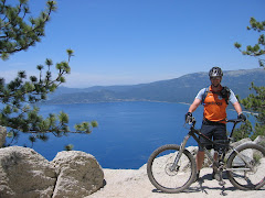
Saturday, I rode with Erwin, one of the SoCal guys from the second run of the day on Friday. We decided to do the Big Boulder trail. Ended up hooking up with two guys, Mack and Mike from the bay area-ish that wanted to do Big Boulder as well. So, at the bottom of Sunrise, we headed off on fire roads to find the top of Big Boulder. Hit some really fun fast rocky sections that reminded me a lot of the wide rock strewn sections coming down from the viewpoint at Porcupine Rim in Moab. It was SWEET! Then, the climb up to the top of Big Boulder. There is a great viewpoint up there, again to rival the magnitude of the view from Porcupine Rim in Moab.


The view was well worth it. However, I was stung by a wasp on the back of the knee while up there. By the time Saturday night rolled around, I couldn’t bend my knee.


Riding down Big Boulder was pretty damn sweet too. FAST, flowy, at times less than 12” wide single track on a semi-buffed, semi-loomy surface. It was a great ride down, and fast too! From there we intersected 3rd divide, I think. Rode back up it a short ways to hit 2nd divide and then down to First. I ran out of water again, about 2/3 of the way down 2nd. It was pretty damn warm too…the warmest it has been on my trip. Made it to town and caught a shuttle back up. 27 or so miles for the day, and despite being a shuttle served ride…I think something like 2300 feet of climbing….most of it while in the neighborhood of 6000 feet of elevation (Monterey on the other hand is sea level…so the altitude was really hurting).


Saturday night, the raffle/swag giveaway from the organizers of the gathering was pretty entertaining. Beer chug races and an inner tube blow up race for nice components like X0 and XTR shifters/derailleurs. I think there was 1 beer chug contest for a Fox 29er fork. Then, there was bike sumo for a Fox TALAS 32 fork. That was entertaining as hell. 2 guys on kids bmx bikes trying to knock each other off the bike without removing a hand from the handlebar or putting a foot down. Turns out Erwin, a guy I rode with twice already, won the bike sumo and the TALAS. After taking a benadryl for the wasp sting, I slept like a rock.


Sunday, I ended up riding with Erwin again and we did Sunrise-Butcher-3rd-1st. The was sting still bothered my knee a bit, and the sking was still hot to the touch. But, there was riding to do.


Got back into town, caught the shuttle back up to camp, broke camp and headed out of town. Overall, Downieville was a great place to ride, lots of good folks riding out there. Kind of like a smaller version of Moab in that regard. But, the town is SO small it is a bit ridiculous. I couldn’t even get a cell phone signal in town. My only regret is not spending more time in town after each ride to lounge in the river a bit…though I did take a dip in Packer Lake after Saturday’s and Sunday’s ride.

Saturday, June 14, 2008

Burn out...

Yep, I think I am just a little bit burned out from riding. Today's ride was at Toro park, with the 1800 foot climb in about 4.5 miles or so. That kind of elevation gain over that distance shouldn't be too bad, but the softness of the soil over good portions of the climb just make that much worse.

I was just all kinds of off today. Felt like crap climbing. Sweating like crazy even though temps were in the 60's. Had some rare high humidity though as it was foggy at the start. Riding down the backside of the 1800 foot hill, I had to slow down. I was on the XC bike, so it wasn't as smooth, but I had a pounding headache that the high speed bumps wasn't helping. Once we got into the canyon, it was better, but I was having all kinds of bike handling problems.

Further evidence that I was a bit off today was that I thought, "it is only a 1.5 hour ride, I don't need 3 liters of water and a water bottle. I'll just go with just a little over 2 liters of water, and also go without electrolyte pills." Well, after about 50 mins of climbing (a little bit of pushing), I made it to the top having consumed at least 1.5 liters of water.


I just didn't have it today, whatever "it" is. But, I think today put me close to a total of 200 mtb miles in two weeks time. It will also likely be my last ride until I get to Downieville and start doing some shuttle served runs at altitude. Hopefully, the replacement bearing for the rear CK hub on the big bike gets to me before I head out of town. I can always scavenege parts from the XC bike as the wheel set on there has the same hub and is burly enough to handle some All Mountain riding. Looking forward to it.

Saturday, June 7, 2008

Mileage

Mileage means more than just one thing to me lately. Since the freight train truck I have maybe averages 15 mpg in mixed city/hwy driving and diesel here has been at 4.99 or higher since before labor day (and well over 4.60 for at least 5 weeks), I have been riding to the trailhead instead of driving. Just doesn't seem worth it to drive 6 miles then hit the trailhead and drive back. I thought to myself, " I could be getting more ride time in by riding out." So, that is what I have been doing.

I did however drive to the trailhead once this week(Thursday). But, that is because I was taking Hannah for a ride...which turned out to be her 4th time hitting the trails with me. Being her 4th ride...she still isn't quite up to being able to ride to the trail and then ride trails and ride back.

This time she was riding an Airborne Liberator (I think that is the model...it is an aluminum framed Ariborne hardtail) that I borrowed from Chris V. At 5'3...he is actually an inch shorter than Hannah, and thus his bikes fit her a LOT better than my bikes do. She really liked it. And had fun. I think I pushed her just a bit further and we did 9.5 miles total, but she wanted to ride again the next day!

Not to sure that was a good idea for her (even with padded shorts, it takes a while for the but to get used to sitting on a saddle for more than just a few mins), I offered to ride down to Ol'Factory later to grab a lat lunch after I got done with my morning ride. So, I knocked out 29.5 miles in a route pretty similar to the ride that marked my first post of the blog. Showered up and then we jumped on the bikes and rode the 1.6 miles to Ol'Factory where I had a beer and Fish Tacos for a much deserved lunch. She needed some supplies at the art supply store, so we stopped by there afterward and then we stopped at the bike shop so that I could get some supplies myself.

Today (Saturday) MORCA (monterey off road cycling association) was putting on a wildcat race, but on the trails here at Fort Ord. I was going to go out and man a checkpoint so that someone else could ride it. Again, not wanting to drive out...I rode the bike out. Turns out that Jason, who I was going to man the checkpoint didn't really want to ride. His main ride was in the shop getting the fork serviced when they banged up the stanchions. So, he had his clunker bike and some beer. So, I ended up riding the race. I didn't really ride it as a race and ended up picking up a couple of newbies. I figured I could make sure they find their way and don't get too lost trying to go from checkpoint to checkpoint. The route for the wildcat turned out to be a long one for me. 28 or so miles. By they time I finished the wildcat, I had 35 miles and change on the odometer.

Hmmm...I could claim 40 MTB miles in one day. So, with that goal in mind, I skipped the post wildcat bar-b-q and rode on home despite several offers of catching a ride back. And so I did it. Turned out to be 41.5 miles. So, with Tuesday at about 29.5, Thursday at 9.5, Friday at 29.5 and today at 41.5....that is....110 MTB miles this week. I think that is probably a personal best for me.

Hopefully all of this mileage will pay off. about another 12 days and I should be starting a two week trip in pursuit of some of northern California's finest singletrack.

Saturday, May 31, 2008

First Post

Okay, so this is my first post. As usual, this bright idea wasn't an original one on my part. I stole it from my buddy Brian back in VA. I think most of writing a blog when I am out on the bike. Then get home and find other things to do.

Today I am waiting for the Detroit Red Wings to start playing some good hockey and take control of this game (game 4 of the Stanley Cup).

Anyway, had a good ride today. About 30 miles....11 on the road, 19 on the dirt. Right around 3 hours of ride time. Haven't had a ride in 6 days...when I rode the Forest Hill Divide Trail in Auburn.

My bike (the Ventana) missed me, and I missed it. Riding that bike is just so much fun to ride. The new Fox fork makes it climb A LOT better. Not as plush as the zoke was, but I'll take the lighter weight and the better climbing. So, today's ride: Like I said, it was good. Did all of my climbs save one in the middle ring. That is a first for me. The one climb that I had to use the inner chain ring is a climb that I don't think is possible to do in the middle ring. At least not on a full suspension bike. Really, I don't know that many people that can clean that climb on a regular basis, regardless of gear selection.

Perhaps doing the $5/gallon diesel fuel is doing me a favor...making me ride to the trailhead more often. I am fortunate to live in an area where I can do ride to the trail head, and even more grateful that it is a trailhead where I can select many, many routes for my ride instead of having to ride the same few miles of trail again and again.

Okay, there is hockey to watch!